A ladder of Colorado hikes
The best hike in Colorado depends on what you are ready for. A walk that is easy for a local can be exhausting for someone who flew in from sea level yesterday, and the step from a foothill loop to a fourteener is bigger than most visitors expect. The trails below are arranged as a ladder, from a paved loop at 6,400 feet to the summit of the highest peak in the state. Each rung builds on the one before, and working up over several days is the safest way to enjoy the higher ones. Distances and elevation gains are approximate; check current conditions with the managing agency before you go.
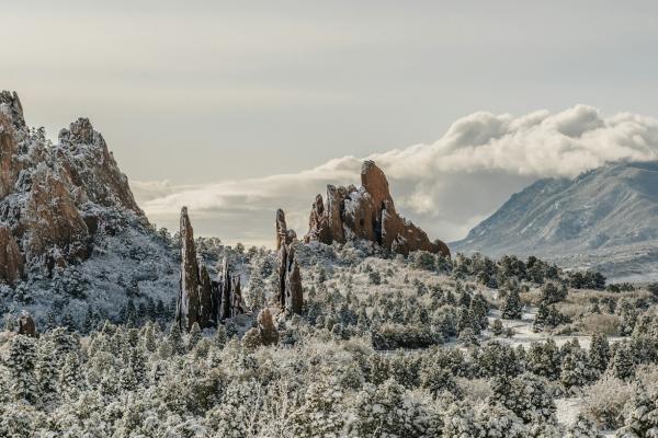
Easy: Perkins Central Garden Trail, Garden of the Gods
Garden of the Gods, on the west side of Colorado Springs, is a city park with free entry and free parking. The Perkins Central Garden Trail is a paved loop of about 1.5 miles with almost no elevation change, winding between red sandstone fins that rise hundreds of feet. It is accessible to wheelchairs and strollers and makes an ideal first-day walk while your body adjusts to the altitude. Go at sunrise or late afternoon for softer light and fewer people.
Easy to moderate: Bear Lake to Emerald Lake, Rocky Mountain National Park
From the Bear Lake trailhead at about 9,450 feet, a 3.6-mile round trip with roughly 650 feet of gain passes Nymph Lake and Dream Lake before ending at Emerald Lake beneath Hallett Peak. It is one of the most popular hikes in the park, with a well-built trail and views at every lake. A timed-entry permit that includes the Bear Lake Road corridor is required in the summer season, or you can use the park shuttle.
Moderate: Hanging Lake and Sky Pond
Hanging Lake, Glenwood Canyon. A steep, rocky trail climbs a little over a mile each way, gaining about 1,000 feet, to a small turquoise lake fed by waterfalls on a travertine ledge. A permit is required to hike it, and access depends on the Interstate 70 corridor through the canyon, which closes at times for rockfall or debris flows. Swimming and touching the water are prohibited, and dogs are not allowed.
Sky Pond, Rocky Mountain National Park. From the Glacier Gorge trailhead, a round trip of roughly nine miles with about 1,700 feet of climbing passes Alberta Falls, The Loch and Lake of Glass before reaching Sky Pond in a cirque beneath the jagged Sharkstooth spires. Near the top, you scramble up a rocky gully beside Timberline Falls, which is wet and can be icy early in the season. It is a long day for a beginner but a classic for fit hikers.
Hard: Ice Lake Basin, near Silverton
In the San Juan Mountains west of Silverton, the Ice Lake trail climbs through forest and two meadow basins to Ice Lake at about 12,250 feet, a round trip of around seven miles with roughly 2,500 to 3,000 feet of gain. The lake's deep blue colour and the wildflowers in July make it one of the most photographed hikes in the state. The climb is steep in places and much of it is above 11,000 feet, so start early to stay ahead of the afternoon storms.
Very hard: Mount Elbert
At 14,433 feet, Mount Elbert is the highest point in Colorado and in the Rocky Mountains. Its standard route, the Northeast Ridge from the North Mount Elbert trailhead near Leadville, is a round trip of about nine and a half miles with roughly 4,500 feet of climbing. There is no technical climbing, but the second half is steep, exposed to weather and above tree line. Most hikers start before dawn, aim to summit by late morning and set a firm turnaround time: if you are not on top by about noon, or thunderclouds are building, turn back. Only attempt it after several days at altitude and a few of the hikes above.
Hiking responsibly
Whatever the trail, carry water, layers, a rain jacket, sunscreen and a map or downloaded route. Tell someone where you are going, as cell coverage is patchy in the mountains. Stay on marked trails, especially above tree line, where alpine plants recover slowly from trampling. Pack out all trash, give wildlife space, and on busy trails yield to uphill hikers. Popular trailheads fill early, so arrive at dawn or use shuttles where they exist.